top of page
Mixed Media Drawing

Mixed Media Drawing

Liard Basin illustrated maps (2025)
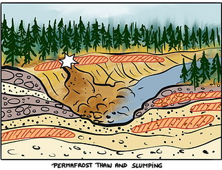
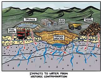
A series of illustrated maps were created to support the development of a visual conceptual model that helps to explain the key processes and stressors (wildfire, mining, permafrost thaw etc.) on the aquatic ecosystem in the Liard River basin. In addition, a series of illustrations were created to explain the key processes of environmental change and concerns across the basin.
This project was a collaboration with the Water Science & Stewardship Branch, Gouvernment of Yukon.


© Yukon Graphic Recording 2026


bottom of page